


Contents
The hydrographic network of the Altai Territory consists of 17 thousand rivers, 13 thousand lakes, which stretch over the territory of the region for 60 thousand km. The total area of all reservoirs located on the territory of the republic occupies 600 thousand km2. One of the largest rivers in Siberia, flowing through the territory of Altai – the Ob, it was formed due to the confluence of full-flowing rivers – the Katun and the Biya.
The length of the Ob flowing within the Altai Territory is almost 500 km, and the area of its basin is 70% of the entire area of the region. The deepest and largest lake in Altai is recognized as Kulundinskoye, its area is 728,8 km2, despite its impressive size in terms of the area it occupies, the lake is shallow and does not exceed 5 m.
In the reservoirs of the Altai Territory, 50 species of fish have received a population. The most common and attractive for fishing: ide, burbot, perch, pike perch, pike, peled, lenok, grayling, taimen. In order to figure out which place to fish and what species exactly, we have compiled a rating of the best places for fishing, as well as a map of locations.
TOP 12 best free fishing spots in the Altai Territory
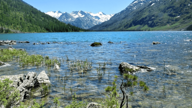
Lower Multinskoye Lake

In addition to the Lower Lake, there are still about forty reservoirs that formed the network of Multinsky lakes, but the most extensive of them in terms of area are:
- top;
- Strong;
- The average;
- transverse;
- Kuyguk;
- Lower.
The lakes are located in the basin of the full-flowing Multa River at the base of the northern slopes of the Katunsky Range covered with taiga forests in the Ust-Koksinsky district.
All lakes are largely identical in terms of the presence and diversity of the ichthyofauna, and therefore are attractive for fishing and recreation. The main differences are the depth of the lake, the color and transparency of the water. A short channel with a high, more than 30 m waterfall, connects the Lower and Middle Lakes, which are surrounded by a picturesque cedar forest.
For adherents of a comfortable stay, on the shores of the Lower Multinskoye Lake, a two-story tourist complex “Borovikov Brothers” was opened, on the territory of which a parking lot was built. The main object of fishing on the Multinsky lakes was grayling and char.
GPS coordinates: 50.00900633855843, 85.82884929938184
Bia River

The source of the Biya is located on Lake Teletskoye, not far from the village of Artybash. The Biya is considered to be the second after the Katun, a significant and full-flowing river of the Altai Mountains. In the Biysk region, they merge, having traveled a long path more than 300 km long, and form the Ob.
The largest tributaries of the Biya are Pyzha, Sarykoksha, Nenya. Almost the entire route of the river through the expanses of Altai, from Lake Teletskoye to Katun, is suitable for tourism and fishing. In its upper reaches they catch large taimen, grayling, and downstream large pike, burbot, ide, sterlet, and bream.
Biya is in demand among lovers of rafting on boats, catamarans and rafts. Due to the large number of rapids and rifts, its upper reaches have become a favorite place for fly-fishers.
GPS coordinates: 52.52185596002676, 86.2347790970241
Shavlinsky lakes

Kosh-Achinsk region has become a place where a network of lakes is located, more than 10 km long. Near the Severo-Chuysky ridge, at an altitude of 1983 m above sea level, in the course of the Shavla River, the largest lake in terms of area, the Lower Lake, was formed. The second largest lake in the network, at a distance of 5 km from the Lower Lake, is the Upper Lake.
Thanks to the Chuisky tract and the road leading to the village of Chibit, it became possible for fishermen and tourists to get to the lakes. But it is worth considering that from the village of Chibit it will still be necessary to overcome the path leading to the Shavla valley through the Oroi pass. For those who manage to overcome this path, the reward will be an unforgettable grayling fishing and stunning views of the lakes.
GPS coordinates: 50.07882380258961, 87.44504232195041
Chulyshman river

Chulyshman, the river is shallow, its depth is not more than 1 m, and its width is from 30 m to 50 m, the length in the vast Ulagansky district of Altai is 241 km. Chulyshman takes its source in Lake Dzhulukul, the mouth is located in Lake Teletskoye.
The largest tributaries of the reservoir are Chulcha, Bashkaus, Shavla. Almost the entire Chulyshman basin flows in sparsely populated and hard-to-reach places. Only in the middle and lower reaches, there are a couple of settlements – the villages of Yazula, Balykcha, Koo. The villages were built for a reason in the middle and lower reaches of the river, this is due to the richness of the plots of ichthyofauna.
The largest populations in Chulyshman were: grayling, Siberian char, osman, taimen, lenok, whitefish, burbot, pike, perch. There are two roads to fishing places, this is a dirt road through the Katu-yaryk pass and a waterway through Lake Teletskoye.
GPS coordinates: 50.84190265536254, 88.5536008690539
Ulagan lakes

In the Ulagansky district of Altai, on the Ulagansky plateau, between the Chulyshman and Bashkaus rivers, there are 20 Ulagansky lakes, surrounded by the Chulyshman highlands from the east, the Tongosh ridge from the west and the Kurai ridge from the south, they have become popular reservoirs among tourists and fishermen. The lakes with the greatest popularity and attendance are:
- Todinkel;
- Tea tree;
- Koldingol;
- Todinkel;
- Sorulukel;
- Baluktukkel;
- Tuldukel;
- Uzunkel;
- Balyktukyol;
- Three-laugh;
- Chaga-keol;
- Cheybek-köl;
- Kidel-kel.
In the waters of these lakes, they catch – grayling, peled, teletsky dace.
In the picturesque places of the mountain taiga and the Ulagansky plateau, among the tundra and meadows identical to the Alpine ones, tourist complexes were built that can provide comfortable rest for fishermen and tourists. The most visited tourist bases in the area surrounding the Ulagansky lakes are the recreation center “Kek-Kol”, “Abchidon”, Balyktu-kel, “Trout”, camping “Ulagan-Ichi”.
GPS coordinates: 50.462766066598384, 87.55330815275826
Charysh River

The left tributary of the Ob, 547 km long, flows through the Republic of Altai and the Altai Territory, starting its course in a mountainous area and smoothly turning into a flat river, all this is the Charysh. Like many rivers of Altai, the Charysh is no exception, it has its own “character”, is famous for a large number of rifts and rapids, as well as a considerable number of tributaries, the largest of which are:
- Kalmanka;
- Idol;
- Maraliha;
- White;
- They struck;
- Frost.
On the picturesque banks of the Charysh, settlements have been built that will help make the stay of fishermen who decide to stay in these places comfortable. You can stop for the night in – Kosobokovo, Ust-Kan, Charyshskoe, Beloglazovo, Ust-Kalmanka, Krasnoshchekovo.
The main objects of fishing in Charysh are grayling, taimen, lenok, nelma, carp, burbot, perch, pike. The best places for fishing, local residents consider parts of the reservoir in the vicinity of the villages of Charyshskoye and Sentelek.
The most visited tourist bases in the areas adjacent to the river are: Chalet “Chulan”, Guest House “Village Grace”, “Mountain Charysh”.
GPS coordinates: 51.40733955461087, 83.53818092278739
Ursul River

The Ust-Kansky and Ongudaisky regions of Altai have become a 119-kilometer territory, along which the streams of the Ursul River rush. Only in the lower reaches the river becomes full-flowing and stormy, in the middle sections from the village of Ulita to the village of Tuekta, it calmly and measuredly tends to the mouth. The upper course is represented by a small mountain river, which has not yet gained strength for swift streams and which is just about to become a full-flowing river of Altai.
On the Ursul River, it is not uncommon to catch trophy taimen, pike perch, and pike. Ursul in local use was nicknamed “Taymennaya River”, and in the regional center a recreation complex was built for guests of Altai and the first leaders, called “Altai Compound”. Grayling fishing continues all year round, with the exception of the freezing period, they also successfully catch – lenok, ide, nelma, chebak.
The district center of Ongudai, the villages of Shashikman, Kurota, Karakol, Tuekta, located on the Chuysky tract, have become an attractive place for the construction of tourist campsites and guest houses.
The most visited tourist bases in the areas adjacent to the river are: the recreation center “Koktubel”, “Azulu”, “Onguday Camping”, the guest house “Altai Dvorik”.
GPS coordinates: 50.79625086182564, 86.01684697690763
Sumulta River

Photo: www.fishong.ru
The right tributary of the Katun, 76 km long, flows through the lands located in the Ongudai region of Altai. Sumulta, as a tributary of the Katun, was formed due to the confluence of two rivers – Bolshaya and Malaya Sumulta. The river with a fast current, clear and cold water, which becomes cloudy only after prolonged rains, has become a promising place for catching grayling.
On the left bank of the river, the Sumultinsky reserve is located, the border of which is indicated by its channel. As already mentioned, it is better to catch grayling during clear weather and during the absence of prolonged precipitation. The most successful areas for fishing, as well as available to anglers, are the areas adjacent to the mouth of the river and its middle part.
In addition to grayling, taimen and lenok are successfully caught in Sumulta, to catch taimen it is worth choosing the lower part of the river, and for lenok, on the contrary, the higher upstream, the larger the population of fish in the area.
Fishing in these places is available only to those who are ready for adventure and are not afraid of difficulties, in order to get to the river bank, you need to walk about 5 km on foot with a crossing over a suspension bridge, or swim across the Katun River in a boat.
At the moment, fishing on the river does not provide comfortable conditions for staying, in the form of guest houses and recreation centers, but on the road passing near the mouth of the river, work is underway to build a guest house.
GPS coordinates: 50.97870368651176, 86.83078664463743
Big Ilgumen River

Before becoming the left tributary of the Katun River, the Bolshoy Ilgumen 53 km “cuts through” the slopes of the Ilgumen Mountain of the Terektinsky Range with its current, and only near the village of Kupchegen, in the area of the Ilgumen threshold, forms a mouth and flows into the Katun River.
A mountain river by the standards of Altai, small, but with a fast current, which is provided by countless tributaries, the most significant in terms of area:
- Kupchegen;
- Chimitu;
- Izyndyk;
- Charlak;
- Jagnar;
- Taldu-Oek;
- To life.
Like Sumulta, Bolshoi Ilgumen is famous for catching grayling, the most promising areas for catching grayling are considered to be the section of the last 7 km of the river adjacent to the mouth. This site is also popular because it is located near the Chuisky tract, which makes it accessible to everyone who wants to go fishing.
The most visited tourist bases in the areas adjacent to the river are: the recreation center “Altay Kaya”, the camp site “Erkeley”, the camping “Shishiga”, “Barrel”, “At the hero”.
GPS coordinates: 50.60567864813263, 86.50288169584111
Gilevsky reservoir

In the triangle between the settlements of Korbolikha, Staroaleiskoye, Gilevo located on the territory of the Loktevsky and Tretyakovsky districts, in 1979 a reservoir was built that fills its water area with the waters of the upper reaches of the Alei River.
The reservoir, which is part of the Liflyandsky Reserve, with an area of 500 hectares, is very rich in the population of silver carp, but in addition to the “lobat” one catches here perch, roach, ide, crucian carp, minnow, ruff, carp and trophy pike.
The deepest section of the reservoir is located in the southeastern part, with a mark of 21 m, the average depth of the reservoir is not more than 8 m. The widest section of the reservoir is 5 km, and its length is 21 km.
The reservoir has become a place of rest for those who are looking for unity with nature, sitting in a fishing chair and with a rod in their hands, and this is facilitated by the remoteness of settlements 5 km from the coastline. Fine white sand, gently sloping bottom, areas with well-heated water contribute to family recreation on the banks of the reservoir.
GPS coordinates: 51.1134347900901, 81.86994770376516
Kucherlinsky lakes

The upper reaches of the Kucherla River, located in the Ust-Kosinsky district of Altai in the vicinity of the picturesque northern slope of the Katunsky Range, became the source of the formation of the Kucherlinsky lakes. Kucherlinsky lakes are located in a network, in the form of three reservoirs under the names – Lower, Big and Middle Kucherlinskoye lake.
Based on the name – Big Lake, it becomes clear that the reservoir is the largest in area among neighboring lakes and has a water area 5 km 220 m long. The average depth of the lake reaches 30 m, and the maximum mark is 55 m with a width of just under 1 km .
The middle lake, located at a distance of 100 m from the Big Lake, its length compared to the Big Lake is less than modest and barely reaches 480 m, with a width of 200 m and a maximum depth of no more than 5 m.
The lower lake is half a kilometer long, 300 m wide and the deepest section is 17 m. All three lakes are surrounded by alpine meadows, the remoteness of settlements makes the places pristine and environmentally friendly, thanks to which a large population of rainbow trout and grayling has developed in the lake.
Access to the lake is possible only if you are ready for horseback riding or hiking along mountain trails.
GPS coordinates: 49.87635759356918, 86.41431522875462
Argut River

One thing can be said about this river – it is a beauty that takes your breath away. Moving along the road from the village of Dzhazator to the mouth of Karagem, which is located in the water area of the Argut River, making your way along mountain paths through two passes, you can enjoy not only the view of the river, but also the mountain lakes located on the left bank, in addition, you can fish on them.
The surroundings are accessible only to people who are ready to rely on their strength and capabilities, the route is available to cyclists and rafting enthusiasts. For those wishing to travel by transport, you should know that it will not be possible to refuel on the way, so it is better to give preference to horse-drawn transportation.
The Argut flows in deserted places in the central part of Altai and is the right tributary of the full-flowing Katun, people can only be met in the area near the village of Dzhazator and the village of Arkyt. The length of the majestic Argut River is 106 km. Its most significant tributaries in terms of area are:
- Kulagash;
- Shavla;
- Look at me;
- Yungur.
It is the mouth parts of the tributaries that are the most suitable for catching fish; grayling, taimen and lenok are caught here.
GPS coordinates: 49.758716410782704, 87.2617975551664
Terms of the spawning ban on fishing in Altai in 2021
- Prohibited periods (periods) for harvesting (catching) aquatic biological resources: a) from May 10 to June 20 – at all water bodies of fishery significance in Kosh-Agachsky, Ust-Koksinsky districts, with the exception of harvesting (catching) aquatic biological resources with one bottom or float fishing rod with shores with a total number of hooks of no more than 2 pieces on the tools of production (catch) of one citizen; b) from April 25 to May 25 – on all other water bodies of fishery significance within the administrative boundaries of the Altai Republic, with the exception of the extraction (catch) of aquatic biological resources of one bottom or float fishing rod from the shore with a total number of hooks not more than 2 pieces on the tools of production (catch) from one citizen. c) from October 5 to December 15 – all types of fish in the lakes of the Ulagansky district; d) from October 5 to December 15 – whitefish in Lake Teletskoye.
2. Prohibited for harvesting (catching) types of aquatic biological resources:
Siberian sturgeon, nelma, sterlet, lenok (uskuch).
Source: https://gogov.ru/fishing/alt